
Tracing Harrison Streets by Parcel
Harrison keeps the strongest street-level trail in parcel systems, not in a public roll of everyone at an address. The Town/Village Assessor maintains permanent property record cards for more than 7,000 residential, commercial, and vacant parcels. Its public tools connect an address to a parcel identifier, an assessed owner, and property details. That makes the parcel the stable starting point when a Harrison street has a changed postal label, a trust owner, or several nearby properties with similar numbers.
Use a consistent chain for a Harrison address search. The chain starts with the physical address, moves through the mapped parcel and assessor record, and then reaches the deed index only when ownership history matters. Each result should be dated. An owner name or mailing address is not the same as a current household, so preserve what the source actually calls the field rather than relabeling it.
- Enter the Harrison street address in Harrison eTRAKiT and save the returned address, parcel ID, owner name, legal description, and date searched.
- Use the Harrison GIS route to browse or select the parcel polygon. Confirm the situs address shown in the map information panel before treating a street match as the same parcel.
- Compare the parcel with the Assessor card or roll. Record the assessment date, because an assessment owner and a recently recorded deed can fall in different time periods.
- Search the current owner as grantee in Westchester Records Online, then use the earlier grantor and legal description to extend the title trail.
- Use permits, certificates of occupancy, or historical directories only for the limited address evidence each source can provide. A voter lookup is person-specific and is not a whole-street roster.
Note: Preserve the street suffix, postal place, parcel identifier, municipality, and access date in each Harrison search note.
Harrison Street Directory Search Fields
The public eTRAKiT parcel search is Harrison's clearest address-to-owner tool. Its Search By control offers Address, Parcel #, and Owner, and the visible operator is Contains. A search can be narrowed by an address string or repeated with the parcel number found on the map. The interface shows only five result rows in the inspected configuration, so a result list is not proof that every address on a Harrison street was returned. The research did not confirm wildcard or complete street-export behavior.
The Harrison eTRAKiT parcel search shows the address, parcel, and owner entry choices used for the street-record workflow.
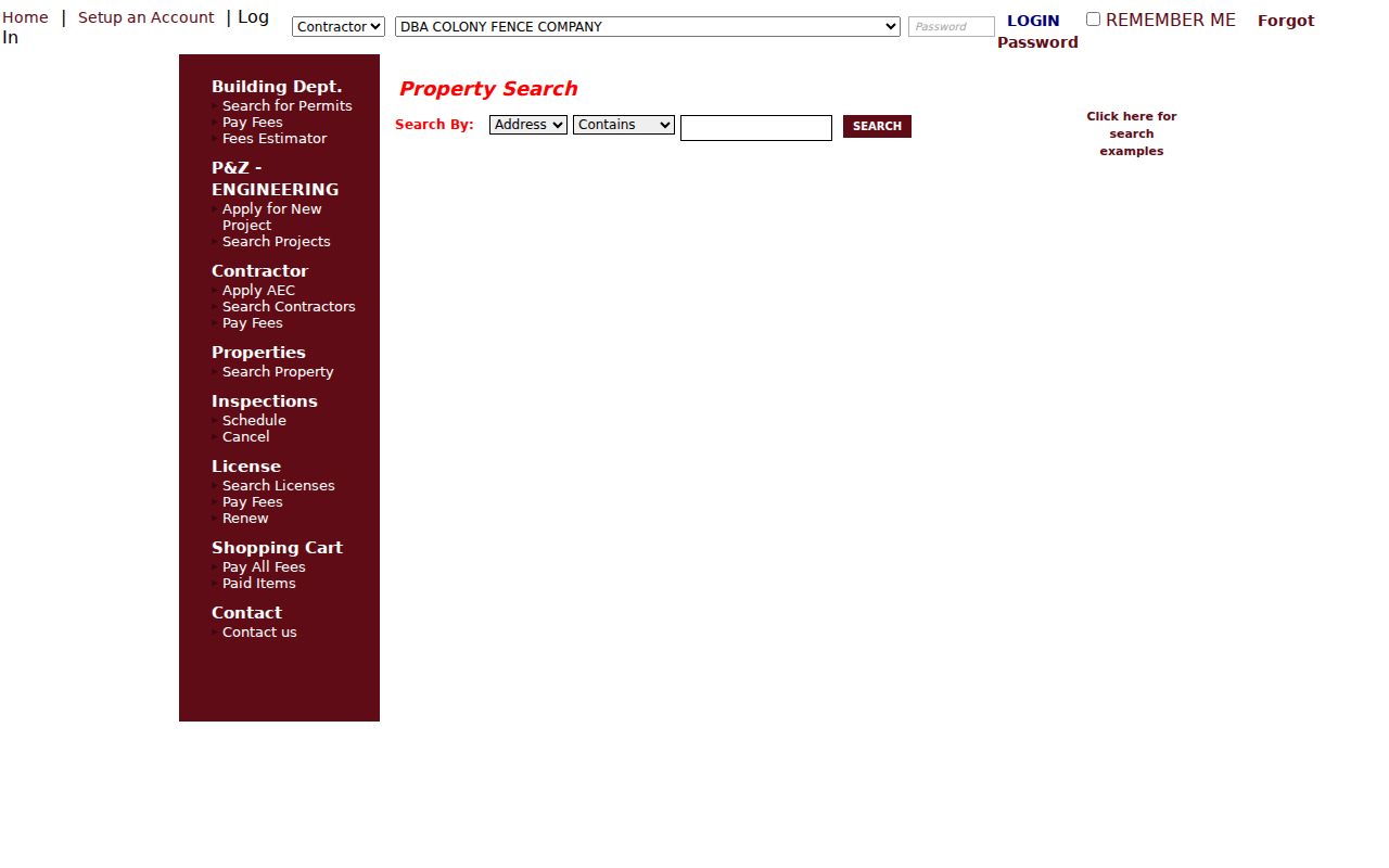
The captured controls support an address-to-parcel handoff. A selected result still needs its own date, parcel key, and field-by-field reading.
| eTRAKiT field or control | Harrison use | Research limit |
|---|---|---|
| Search By | Choose Address, Parcel #, or Owner | Selection is required for a search |
| Search text | Enter the selected address, parcel identifier, or owner string | Minimum input format was not displayed |
| Operator | Contains was visible during inspection | Other options were not confirmed |
| Search | Runs the selected parcel query | Use the returned result as a dated record reference |
| Map On / Map Off | Show or hide the map around a result | Not a verified street-wide export tool |
| Print / Export To Excel | Preserve the current result view when enabled | Scope of exported rows was not documented |
| Results pages | Move through matching parcel rows | Five rows were shown in the inspected view |
| Parcel Info / Owner Info | Review parcel and assessed-owner information | Owner and mailing fields need separate reading |
| Restriction Details / Land Use | Check recorded restrictions and use classification | Classification is not a resident list |
| Building / Legal Desc / Inspections | Review physical, land-identity, and associated inspection tabs | Subfields depend on the selected record |
The visible demo text on the portal is generic interface content, not a Harrison property result. A real street directory entry should be drawn only from a selected Harrison parcel. The public lookup remained available after September 3, 2024, when the Building Department stopped accepting new electronic applications through eTRAKiT. Existing application functions, payments, comments, and inspections remained part of the portal's stated role.
Harrison Street Parcels on GIS
Harrison Engineering directs researchers to Westchester County GIS data and says the Town/Village uses the same information. The confirmed parcel-map workflow is simple: browse along the street, select a highlighted polygon, read the address and parcel information panel, then take that key to eTRAKiT or the Assessor. Selecting adjacent polygons can clarify which parcel belongs to a corner or an irregular lot. Engineering is the appropriate Harrison contact when a map and an address record do not agree.
The available static capture confirms a selected parcel and a situs address. It does not confirm a complete live-layer list, a radius tool, or a map export function. Do not assume that zoning, flood, tax-district, or other layers are available unless the live viewer supplies them. eTRAKiT does state that public parcel lookup can show flood-zone information, but that fact should not be expanded into an unverified GIS feature list.
- Parcel
- A defined piece of land used as a cross-system property key. Copy the Harrison identifier exactly because its published format was not documented.
- Situs address
- The physical location of the parcel. GIS, permits, inspection work, and property navigation commonly use this address.
- Legal description
- A land description that can use a lot, block, map reference, or metes and bounds. It remains useful when postal wording changes.
- Criss-cross directory
- A historical address-to-occupant directory. No confirmed Harrison-specific run was found, so regional volumes must be labeled by their own locality and year.
Harrison Street Directory Record Coverage
A Harrison street directory is a chain of separate address-keyed records. The table distinguishes property ownership from address context, building history, and person-specific registration information. It also shows why a complete street-by-street list of occupants cannot be claimed from these sources.
| Address record | Harrison or county keeper | What it can establish | Access route and limit |
|---|---|---|---|
| Parcel card and assessment roll | Harrison Assessor | Assessed owner, parcel, value, and assessment context | Assessor page, eTRAKiT, roll PDFs, or office; not a household list |
| GIS parcel view | Harrison Engineering / Westchester GIS | Parcel geometry, selected address, and nearby parcels | Public data route; exact live controls were not verified |
| Deed or map index | Westchester County Clerk | Recorded transfer parties and legal-description trail | WRO index is free; images and reports require registration or paid access |
| Permits, COs, violations | Harrison Building Department | Property work, status, and selected file references | Parcel lookup, municipal search, or FOIL; interior material has access limits |
| Tax bill or roll | Harrison Receiver / Assessor | Taxpayer and taxing-district context | Mailing information is correspondence evidence, not occupancy proof |
| Voter registration | New York State Board of Elections | Person-specific registration workflow | County, name, date of birth, ZIP, and address inputs; not a street roster |
| Historical directory lead | Libraries and archives | Past address-to-householder context where a volume covers the place | No confirmed Harrison criss-cross run |
Parcel ID and legal description are the best bridge between the current Harrison address and county land records. The street string remains useful, but it can change with a postal place, an old number, or a subdivision. The Harrison city directories collection page covers historical directory leads without turning a regional volume into a current street roster.
Note: A property result documents a parcel relationship, while a dated deed or permit documents a separate event.
Harrison Street Address Key Differences
The situs address is the physical Harrison parcel location. A tax or assessor mailing address is the place where correspondence goes. It can belong to another residence, an attorney, a trust, a company, an estate, or a servicer. A mailing address can therefore be helpful context, but it cannot establish that a named person lives at the situs. A deed may instead use a legal description, which identifies land without relying on postal formatting.
Keep all three identifiers in the Harrison street record notes: situs address, mailing address if shown, and legal description or lot information. A recent transfer, a parcel split, or a change-of-address lag can make the assessed owner, deed grantee, and mailing addressee look different. The sensible sequence is owner name to parcel ID to deed description, followed by separate current evidence only when an authorized source supplies it.
Harrison Street Owners in WRO
Westchester Records Online is the County Clerk's land, legal, map, and trade-record route. Its public description says the index reaches from eighteenth-century deeds to judgments entered the previous week. That description is about index coverage, not a guarantee that every image is online. The free public index is separate from registered and paid image or report access. Harrison land records are handled through the County Clerk, with counter access in White Plains rather than at the Town/Village offices.
For a Harrison street title trail, search the current assessed owner as grantee. Record the grantor, grantee, recording or index date, document reference, and legal description. Then look for the grantor as an earlier grantee. Continue only while the legal description supports the same land. Subdivision maps and lot changes can break a simple street-number search. When older material is needed, Westchester County Archives research by mail lists grantor and grantee deeds from 1680 to 1907, mortgages from 1680 to 1897, and maps from about 1766 forward.
Note: Treat a WRO index hit as a record reference until the relevant image or clerk copy confirms it.
Harrison Street Permit Records
Building material adds history to a Harrison street address, but it does not identify everyone who used the property. eTRAKiT can expose parcel ID, acreage, owner, and flood-zone information. For permits, certificates of occupancy, surveys, or violations, Harrison's municipal search form asks for an owner's last name, property address, block and lot, and the requested categories. The stated municipal-search fee is $50 for a residential one- or two-family property and $100 for commercial, multi-dwelling, mixed-use, or commercial property.
Actual Building Department files follow a more limited path. The Town directs approved FOIL requests through the Town Clerk. A nonowner needs written owner permission for interior floor plans; without that permission, material is available without the floor plans. This distinction matters when a street search moves from a public parcel card to a more sensitive building file. Ask for a specific address, parcel, record type, and date range instead of assuming every file is visible online.
Harrison Street Voter Lookup Limits
The New York State Voter Lookup uses a county selection, last name, first name, date of birth, ZIP Code, and address information in its public flow. Westchester is the county choice for Harrison. That design supports an individual registration or poll-site inquiry. It does not provide a public form for listing every registrant on a Harrison street or at a particular address.
Registration records are public under Board of Elections supervision, but New York Election Law includes withheld identifiers and confidential-voter protections. A full-file request has an elections-purpose requirement, and confidential voters or Address Confidentiality Program participants may not expose a physical residence address. A nonmatch can reflect a name variation, registration status, a protected address, or a changed record. It cannot show that someone never lived on the street.
Harrison Street Postal Labels
Harrison is a Town/Village in Westchester County with Harrison, West Harrison, and Purchase as named communities or areas. A postal city line is not a municipal-boundary ruling. The 10528 and 10577 postal areas serve Harrison context, while 10580 and 10604 also serve other county regions. In March 2024, USPS changed the 10604 place name from White Plains classified branch to West Harrison while retaining the ZIP. That change can produce older and newer search results with different place labels for the same ZIP.
Confirm municipality through the parcel, GIS, and Assessor records instead of using the postal line alone. Street-level postal geography is explored in the Harrison ZIP directory, which separates delivery labels from parcel identity. This is especially useful before carrying a street result into WRO or a municipal record request.
Harrison Street Directory Historical Leads
Criss-cross directories can connect a past address to a householder, but research did not locate a confirmed Harrison-specific criss-cross run. The defensible fallback is a carefully dated regional search. The New York State Library lists a Westchester directory for 1860/61 and White Plains directory runs from 1903/04 through 1932 for onsite use. Those entries may be useful leads for a Harrison family or a nearby postal place, but they are not proof that every Harrison address appears in the volumes.
For older parcel context, combine a regional directory lead with an archived deed index, a map, or a census source. Westchester County Archives provides historic map and deed channels, while the Town Historian can help with local records and place history. Each source should retain its own place name and date. A historical address result is a dated clue, not a present-day street directory listing.
Note: Regional directory coverage must be stated precisely before it is used to connect a Harrison address and household.
Harrison Street Directory Record Limits
Address-keyed public records do not provide a complete list of household members, guests, children, mail recipients, utility customers, or every occupant. A recorded owner may be an entity, trust, estate, or person who receives mail elsewhere. DMV addresses and driver-license information are protected, and utility customer data is not a public Harrison street directory source. Court, vital, police, and voter material each carries its own access rules.
Use the public property, map, deed, and permit routes for personal, lawful research and civic or family-history questions. Do not use an address record to stalk, harass, intimidate, or harm a person. When a record is incomplete or conflicted, ask the custodian for the source that actually holds it rather than filling the gap with assumptions.
Privacy boundary. Harrison parcel and deed records can support property research, but they never justify publishing a household roster or pursuing private contact information.